Bryansk Oblast
| Bryansk Oblast (English) Брянская область (Russian) |
|
|---|---|
| - Oblast - | |
.svg.png) |
|
| Coordinates: | |
 Coat of arms of Bryansk Oblast |
 Flag of Bryansk Oblast |
| Anthem | The Bryansk Forest Sternly Stirred |
| Political status | |
| Country | Russia |
| Political status | Oblast |
| Federal district | Central[1] |
| Economic region | Central[2] |
| Administrative center | Bryansk |
| Official language | Russian[3] |
| Statistics | |
| Population (2002 Census)[4] | 1,378,941 inhabitants |
| - Rank within Russia | 38th |
| - Urban[4] | 68.4% |
| - Rural[4] | 31.6% |
| - Density | 39.51 /km2 (102.3 /sq mi)[5] |
| Area (as of the 2002 Census)[6] | 34,900 km2 (13,475.0 sq mi) |
| - Rank within Russia | 62nd |
| Established | July 5, 1944 |
| License plates | 32 |
| ISO 3166-2:RU | RU-BRY |
| Time zone | MSK/MSD (UTC+3/+4) |
| Government (as of July 2009) | |
| Governor[7] | Nikolay Denin[8] |
| Legislature | Oblast Duma[9] |
| Charter | Charter of Bryansk Oblast |
| Official website | |
| http://www.bryanskobl.ru/ | |
Bryansk Oblast (Russian: Бря́нская о́бласть, Bryanskaya oblast) is a federal subject of Russia (an oblast). Its administrative center is the city of Bryansk. Population: 1,378,941 (2002 Census);[4] 1,474,785 (1989 Census).[10]
Contents |
History
The territory of Bryansk has been inhabited since ancient times by Slavic tribes. In the 9th to 11th centuries they lived along the banks of the Desna and in the forests of the land between the Desna and the Oka River. The city of Bryansk was established in 985.[11]
Bryansk remained poorly attested until the Mongol invasion of Russia. It was the northernmost of the Severian cities in the possession of the Chernigov Rurikids and the principality of Novgorod-Seversky. After Mikhail of Chernigov was murdered by the Mongols and his capital was destroyed, his son moved his seat to Bryansk. In 1310, when the Mongols sacked the town again, it belonged to the principality of Smolensk. After the demise of Chernigov by the Mongols, the Principality of Bryansk was formed. In 1356 Bryansk territory was under the authority of the Grand Duchy of Lithuania.
Great Duchy of Moscow conquered Bryansk following the Battle of Vedrosha in 1503. The town was turned into a fortress which played a major role during the Time of Troubles. Peter the Great incorporated Bryansk into the Kiev governorate, but Catherine the Great deemed it wise to transfer the town to the Oryol Guberniya in 1779. She also promulgated the town's coat of arms. Bryansk became the duchy's south-western outpost in the fight against Lithuania, Poland and Crimean Khanate. In 1618 the Deulino Armistice saw the southern and western area of the Bryansk region temporarily ceded to Poland.
After the expulsion of the Poles and reunification with Russia in 1654, all the left bank of the Dnieper (Malorossiya), including the south-western area of Bryansk, was divided into hundreds of administrative regiments. One of the largest was Starodubaka. In 1781 these regiments merged into districts and several territories became what is now Chernigov province.
In 1709 part of the Bryansk (Bryansk, Karachevsky, Sevsk and Trubchevsk counties) belonged to Kiev Province. In 1727 Sevsk Province became part of the newly formed Belgorod Oblast.
The 17th and 18th centuries were a period of significant regional economic development. The industrial revolution began in the 18th century, particularly in the eastern part of Bryansk and due to its reserves of sand and saw the growth of the glass industry.
On April 1, 1920 the Bryansk Province was established but on October 1, 1929 it was incorporated into the Western Region. On September 27, 1937 the Central Executive Committee decided to abolish the Western region, dividing it by Smolensk and Orel oblasts. The current territory of Bryansk region became part of the Oryol region.
In August-October 1941 the region was occupied by Nazi troops. From the first days of occupation, the struggle against the invaders took the character of a popular movement. In the Bryansk there were about 60,000 guerrillas from the guerrilla compounds of SA Kovpak, AF Fedorov and AN Saburov. It resulted in the destruction and burning of many towns and villages, affecting some 111,000 homes and many important industrial enterprises. After the liberation of territory (August-September 1943), extensive restoration work commenced.
The modern Bryansk Oblast was established by the Decree Presidium of the Supreme Soviet of the USSR on July 5, 1944.
Geography and environment
Bryansk Oblast lies in western Russia in the western part of the East European Plain, occupying the middle part of the Desna River basin. The area, covering 34,900 km² is bounded to the north with Smolensk Oblast, with Kaluga Oblast and Orel Oblast in the south and southeast and borders Kursk, Chernihiv and Sumy with the Ukraine to the southwest and Gomel and Mogilev in Belarus to the northwest.
The climate is temperate continental. The average temperature in January is -7 - 9 °C. The average July temperature is between 18 and 20 °C. About a quarter of the total area is covered by forests, mainly coniferous, mixed and deciduous, as well as forest-steppe.
Natural resources include deposits of sand, clay, chalk, marl, and other building materials, as well as phosphorite.
As a result of the Chernobyl disaster on April 26, 1986, part of the territory of Bryansk region has been contaminated with radionuclides (mainly the Klimovsky, Klintsy, Krasnogorsk, Surazh and Novozybkov areas). In 1999, some 226,000 people lived in areas with the contamination level above 5 Curie/km2, representing approximately 16% of the Oblast's population.
Heraldry
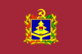
The Flag of Bryansk Oblast represents a panel burgundy with a ratio of 1:1,5. In the center of the cloth is placed coat of arms of the Bryansk region. The coat of arms is a blue shield representing Slavic unity between the states of Russia, Belarus and Ukraine. In the upper part of the shield is a stylized golden spruce with a three-tiered crown representing the forests of Bryansk. The flag is burgundy in color, representing the color of the banners under which the army and guerrillas fought for the liberation of Bryansk.
Administrative divisions
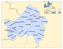
Bryansk Oblast is divided into 27 districts (raions) and 4 cities. Together they comprise 12 towns, 24 urban-type settlements, and 224 selsoviets.
Demographics
- Births (2008): 14,319 (11.0 per 1000)
- Deaths (2008): 23,197 (17.8 per 1000)
Births increased by 7.8% and deaths remained the same in 2008 compared to 2007.[12]
Culture
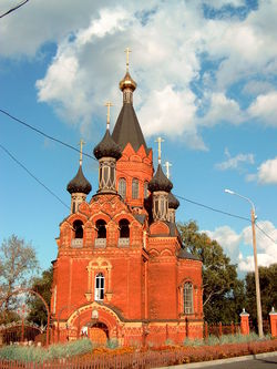
There are 17 museums in Bryansk Oblast.[11] The main cities have many major architectural and archeological monuments. In Bryansk is the Svenski monastery, Chashin mound (the birthplace of Bryansk), the ancient Kremlin of Bryansk on Pokrovskaya Mountain, Peter and Paul monastery etc.[11] Main churches include the Voksresenskaya, Vvedenskaya and Spaso-Grobovskaya, Pokrovskaya and Gorne-Nikolskaya.
Klintsy is the second largest city of Bryansk oblast and was one of the Old Believers’ centers, now known for its textile industry and its ancient temples. Trubchevsk is noted for its archeological and architectural monuments, in particular the Trinity Cathedral of the 13th-19th centuries with its tomb.[11] The museum contains some valuable items dated to the 6th-7th centuries.[11]
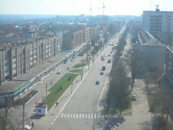
Transport
.jpg)
A large railway junction is located in the capital of Bryansk. Most rail lines in the oblast are electrified, using AC power. In connection with the border situation, Bryansk there are several major customs terminals.
The region is crossed by the M3 Moscow—Kiev highway and the M13 Bryansk-Novozybkov-Boundary Belarus—(Kobrin), and 14 kilometers from the regional center is Bryansk International Airport.
References
- ↑ Президент Российской Федерации. Указ №849 от 13 мая 2000 г. «О полномочном представителе Президента Российской Федерации в федеральном округе». Вступил в силу 13 мая 2000 г. Опубликован: "Собрание законодательства РФ", №20, ст. 2112, 15 мая 2000 г. (President of the Russian Federation. Decree #849 of May 13, 2000 On the Plenipotentiary Representative of the President of the Russian Federation in a Federal District. Effective as of May 13, 2000).
- ↑ Госстандарт Российской Федерации. №ОК 024-95 27 декабря 1995 г. «Общероссийский классификатор экономических регионов. 2. Экономические районы», в ред. Изменения №5/2001 ОКЭР. (Gosstandart of the Russian Federation. #OK 024-95 December 27, 1995 Russian Classification of Economic Regions. 2. Economic Regions, as amended by the Amendment #5/2001 OKER. ).
- ↑ According to Article 68.1 of the Constitution of Russia, Russian is the official language on the whole territory of the Russian Federation. Article 68.2 further stipulates that only the republics have the right to establish official languages other than Russian.
- ↑ 4.0 4.1 4.2 4.3 Федеральная служба государственной статистики (Federal State Statistics Service) (2004-05-21). "Численность населения России, субъектов Российской Федерации в составе федеральных округов, районов, городских поселений, сельских населённых пунктов – районных центров и сельских населённых пунктов с населением 3 тысячи и более человек (Population of Russia, its federal districts, federal subjects, districts, urban localities, rural localities—administrative centers, and rural localities with population of over 3,000)" (in Russian). Всероссийская перепись населения 2002 года (All-Russia Population Census of 2002). Federal State Statistics Service. http://perepis2002.ru/ct/html/TOM_01_04_1.htm. Retrieved 2010-03-01.
- ↑ The value of density was calculated automatically by dividing the 2002 Census population by the area specified in the infobox. Please note that this value may not be accurate as the area specified in the infobox is not necessarily reported for the same year as the Census (2002).
- ↑ Федеральная служба государственной статистики (Federal State Statistics Service) (2004-05-21). "Территория, число районов, населённых пунктов и сельских администраций по субъектам Российской Федерации (Territory, Number of Districts, Inhabited Localities, and Rural Administration by Federal Subjects of the Russian Federation)" (in Russian). Всероссийская перепись населения 2002 года (All-Russia Population Census of 2002). Federal State Statistics Service. http://perepis2002.ru/ct/html/TOM_01_03.htm. Retrieved 2008-10-17.
- ↑ Charter, Article 41.3b
- ↑ Official website of Bryansk Oblast. Nikolay Vasilyevich Denin, Governor of Bryansk Oblast (Russian)
- ↑ Charter, Article 41.3a
- ↑ "Всесоюзная перепись населения 1989 г. Численность наличного населения союзных и автономных республик, автономных областей и округов, краёв, областей, районов, городских поселений и сёл-райцентров. (All Union Population Census of 1989. Present population of union and autonomous republics, autonomous oblasts and okrugs, krais, oblasts, districts, urban settlements, and villages serving as district administrative centers.)" (in Russian). Всесоюзная перепись населения 1989 года (All-Union Population Census of 1989). Demoscope Weekly (website of the Institute of Demographics of the State University—Higher School of Economics. 1989. http://demoscope.ru/weekly/ssp/rus89_reg.php. Retrieved 2007-12-13.
- ↑ 11.0 11.1 11.2 11.3 11.4 "Bryansk Oblast". Chernobyl Info. http://www.chernobyl.info/index.php?userhash=&navID=561&lID=2. Retrieved May 31, 2010.
- ↑ Demographical statistics for Bryansk (in Russian)
Sources
- Брянская областная Дума. №7-З 26 января 1996 г. «Устав Брянской области», в ред. Закона №31-З от 4 мая 2009 г. (Bryansk Oblast Duma. #7-Z January 26, 1996 Charter of Bryansk Oblast, as amended by the Law #31-Z of May 4, 2009. ).
External links
- (Russian) Official website of Bryansk Oblast
- (English) Bryansk oblast nature views